Showing posts with label fires. Show all posts

Friday, April 13, 2018

Making a Homestead Evacuation Plan

This article was originally published by Daisy Luther at The Organic Prepper


With wildfire season approaching in California, my thoughts are with my many friends there who have small farms. Even if you don’t live in a wildfire zone, if you raise livestock, you need to have a homestead evacuation plan. Any place can have a barn fire, a chemical spill, or other environmental emergencies.


I’ve written quite a lot about evacuations since my family and I were right on the verge of it during the King Fire. Fires can approach shockingly fast, and being ready before there is ever a hint of smoke in the air is the best way to get out quickly when the time is short.


But things change dramatically when you add a farm or homestead to the mix. Suddenly, you have more living creatures in your charge than you do space in the vehicle. You absolutely must have a plan in place before a disaster occurs, because if you wait for the evacuation order, you’ve waited too long.


Create a homestead evacuation plan.


Here are some of the things that I learned about homestead evacuation. Use this to create your own plan, because disasters can strike anywhere and we all have different resources, livestock, and circumstances.


Be aware of what’s happening nearby. When I lived in California, I haunted the local boards that discussed fires and other events. I had friends who were former firefighters and subscribed to phone notifications from the local sheriff’s department. If there was a fire or mudslide nearby, I knew about it while it was still miles from me. That way, I could assess my plan and see if action needed to be taken immediately, or if I just needed to stay on top of the situation.


Figure out where you’ll take your livestock. Often, local fairgrounds will open their facilities for farmers to bring evacuated livestock. Sometimes veterinarians and kennels will also accept evacuated animals. If you are in contact with other farmers, they may be able to make room for your animals. I belonged to a local homesteading group at the time, and we all made space for animals, trailers, and RVs if we could to help our friends during fire season.


Evacuate livestock early if you can. The last fire that was nearby was called the Trailhead Fire, and it consumed 5,646 acres over the course of 20 days. Toward the end, when it drew closer to our farm, I evacuated all our chickens to a friend’s farm that was out of the danger zone. That gave me the peace of mind to know that if we had to evacuate for real, I only had to grab cats, dogs, and kid, which would have been far faster than chasing a bunch of panicked hens.


Have a way to transport your animals. You will either need a trailer, pens that can go into the back of a truck, or crates that can hold your livestock. You may need help from friends with trailers if you have a lot of animals. Have these things ready so that you aren’t trying to figure out how to move the animals when a fire is approaching.


Have a plan for last-minute homestead evacuation. This is every farmer’s nightmare because if the fire is approaching fast, you may not be able to load up all your animals in time.


  • Have trailers and trucks close to the livestock area for quick evacuation.

  • If you think you may need to evacuate, contain your livestock in the smallest area possible for ease of loading. For example, if your chickens normally free-range, keep them contained in a yard around their coop so you have a better chance of catching them. Close off the gates to the larger pastures and keep other livestock in the area closest to the trailers.

  • Practice loading up. This way, the animals get used to being loaded and are less likely to panic and fight you. Secondly, you know which animals are going to be the most uncooperative and you also have a feel for how long it takes to load them all.

  • Have blinders on hand. This may be nothing more than a piece of cloth or a fabric bag, but if your animals are panicking, it can be easier to lead them out if they can’t see the threat. Most people think only of horses needing blinders but it can be far easier to lead goats and cows this way too.

  • Give every person a job. Even younger children may be able to help round up chickens or gather feed. Be sure that everyone knows what to do beforehand so that you can all work together quickly and efficiently.

  • Remember that if there is a threat like a nearby fire, animals are much more likely to panic due to fear. This means it will probably take longer to load them up.


Know what to do if you can’t evacuate the livestock. If there is no time to load the livestock, at least turn them loose so they have a chance at escaping the flames. If your family is at risk of dying in the fire, you will have to evacuate and leave the animals behind. It’s a horrible choice but could be necessary. Remember the Napa Valley fires last summer? Some people had only moments to flee fast-moving infernos.


Have you ever been through a homestead evacuation?


Have you had the experience of evacuating a homestead? If so, please share your story and tips in the comments section below.


The Pantry Primer


Please feel free to share any information from this article in part or in full, giving credit to the author and including a link to The Organic Prepper and the following bio.


Daisy Luther is the author of The Pantry Primer: A Prepper’s Guide To Whole Food on a Half Price Budget.  Her website, The Organic Prepper, offers information on healthy prepping, including premium nutritional choices, general wellness and non-tech solutions. You can follow Daisy on Facebook and Twitter, and you can email her at daisy@theorganicprepper.ca</e


Sunday, December 31, 2017

Top Ten Global Weather/Climate Events of 2017

A Year of Landfalls (Hurricanes Harvey, Irma, and Maria) and Firestorms (California)


December 29, 2017


In 2017, the atmosphere seemed to have it in for the United States. Globally, the lion’s share of destruction from each of the world’s four costliest weather-related disasters occurred within U.S. states and territories, and each one involved either hurricanes or wildfires. Through September, NOAA tallied 15 U.S weather disasters in 2017 with a cost of at least $1 billion, and the December wildfires in Southern California may well add another billion-dollar disaster to the total. This would tie 2017 with 2011 for the most billion-dollar weather disasters in any year in U.S. history.


Granted, the U.S. is a meteorological crossroads that’s renowned for getting virtually every type of meteorological mayhem, but it’s unusual for the nation to have such a lopsided share of the global toll from a year’s worth of weather/climate disasters. One preliminary damage assessment put the U.S. damage from Maria, Harvey, and Irma at $207 billion, with another $25 billion in non-U.S. damage. Thus, our picks below for the planet’s highest-impact weather and climate events of 2017 are very U.S.-centric.


Three events tied for #1 in 2017: Hurricanes Harvey, Irma, and Maria


The most hellacious series of Atlantic hurricanes since 2005 produced catastrophic damage in a number of Caribbean nations as well as Puerto Rico, the U.S. Virgin Islands, and the U.S. mainland. One reason: at the peak of hurricane season, sea-surface temperatures were at near-record warm levels across most of the tropical Atlantic. Moreover, upper-level winds (with an assist from La Niña) were unusually supportive for allowing hurricanes to thrive (bringing low wind shear), and steering currents favored trajectories toward land, with a grand total of 23 landfalls for the year. The period from late August to early October saw a nearly unbroken string of Atlantic hurricanes in progress, and September produced the largest amount of accumulated cyclone energy (ACE) of any month on record.


Figure 1. First-light GOES-16 image of Hurricane Maria taken at 7:15 am EDT September 20, 2017, just after the hurricane had made landfall in Puerto Rico as a top-end Category 4 storm with 155 mph winds. Maria’s eye was obscured by clouds due to interactions with land. Image credit: NOAA/RAMMB.


1. Hurricane Maria


Hurricane Maria hit the island of Dominica in the Caribbean as a Category 5 hurricane with 160 mph winds, then powered through the Virgin Islands and Puerto Rico as a top-end Category 4 storm with 155 mph winds, causing catastrophic damage and at least 47 deaths outside of Puerto Rico. The death toll from Maria in Puerto Rico is likely to top 1,000 when indirect deaths that occurred in the weeks and months after Maria’s passage are fully taken into account. This would make Maria only the second hurricane since 1928, along with Katrina of 2005, to have caused at least 1,000 deaths in the U.S. or its territories. Total damage across the Caribbean from Maria has not yet been fully tallied, but some estimates are in excess of $100 billion (insured plus uninsured damage), which would make Maria more costly than any hurricane except Hurricane Katrina ($161 billion in damage in 2005). Overall, it appears that Maria will be the deadliest Atlantic hurricane since 2005’s Stan, which took more than 1,500 lives in Guatemala and another 150+ in neighboring countries.


Maria also became a political flash point, as it highlighted Puerto Rico’s fragile infrastructure and the lack of urgency one might see in recovery efforts for a similar disaster in a U.S. state versus a territory. More than a million residents still lacked power as of late December. According to New York Times reporter Frances Robles, the U.S. Corps of Engineers estimates that power will not be fully restored to rural parts of Puerto Rico until the end of May—a full eight months after Maria.


Figure 2. Storm-total rainfall from Hurricane Harvey, August 24 – 31, 2017. Harvey dumped over 40” (yellow colors) in Houston, with isolated amounts in excess of 50” (pink colors) south of Houston and northwest of Port Arthur. Image credit: NOAA.


Tied for #1: Hurricane Harvey


Hurricane Harvey was spectacular in terms of rainfall, as a result of its slow movement near the southeast Texas coast following landfall at Category 4 strength just north of Corpus Christi. At least 40” of rain fell across a gigantic area from Houston to Port Arthur—larger than the entire state of Delaware. The storm total of 60.58” at Nederland, TX, was the heaviest single amount ever recorded from a tropical cyclone or its remnants in the U.S. One analysis found that Houston could expect Harvey-like rains only about once every 2000 years—but that climate change is already making such rains far more likely.


Harvey caused at least 84 direct and indirect deaths, primarily from massive flooding across southeast Texas, including many places outside the 100-year flood plain. The total cost of Harvey (including insured and noninsured losses) was estimated by insurance broker Aon Benfield at $90 billion. Among U.S. hurricanes, this comes in behind only the $161 billion in total damage from 2005’s Hurricane Katrina, as estimated by NOAA’s National Centers for Environmental Information. Hurricane Maria may exceed Harvey’s damage once the final numbers are in, though.


Figure 3. Recently planted palm trees lie across a road in Miami Beach, FL, on Sunday, September 10, 2017, due to Hurricane Irma’s landfall. Image credit: Wilfredo Lee/AP.


Also tied for #1: Hurricane Irma


Irma was neither the deadliest or most destructive Atlantic hurricane of 2017—but in most other years, it would have been an epic disaster all its own. Irma churned across or near several Caribbean islands as a Category 5 storm packing 185 mph winds, the strongest winds of any tropical cyclone on Earth this year. Irma made destructive landfalls in Antigua and Barbuda, Saint Martin, Anguilla, Turks and Caicos, The Bahamas, and Cuba, as well as the United States. Before it moved up the west coast of Florida, Irma angled just far enough leftward to rake the north coast of Cuba, a shift that resulted in 10 deaths and $2.1 billion in damage there. Had Irma not been disrupted by its encounter with Cuba, it might have produced far greater destruction in Florida. All told, Irma took 124 lives and wreaked an estimated $50 billion in total damage along its path, according to Aon Benfield.


Figure 4. Christmas decorations illuminate a house in Carpinteria, Calif., as the growing Thomas Fire advances toward Santa Barbara County seaside communities on December 10, 2017. Image credit: David McNew/Getty Images.


4.  California wildfires (October-December)


After an unusually slow start to the U.S. fire season caused by a wet winter, the fire season of 2017 put on an intense blitz of the Western U.S., burning 9.6 million acres–the third highest total since accurate records began in 1960, according to the National Interagency Fire Center. The last three months of the year brought two devastating clusters of wildfire to California. The stage for disaster was set by a near-record wet winter in 2016–17, which led to a bumper crop of fire-vulnerable shrubs and grasses. California’s hottest summer on record eventually left the fresh vegetation tinder-dry, and cool-season rains were unusually slow to return to the state.


The first of the year’s two firestorms burst into being on the night of October 8-9, when a fierce round of hot, dry winds gusting to more than 60 mph swept through the North Bay Hills of California. The strong winds tossed embers well ahead of the fire line, leading to extremely rapid fire spread. Many residents had only a few scant minutes to evacuate. The Tubbs Fire pushed from the urban/wildland interface well into the city of Santa Rosa, scorching more than 36,000 acres and consuming 5,643 structures in all—almost twice the structural toll of any other fire in Cal Fire records. At least 44 people died as a direct result of the October fires, the largest U.S. death toll from a wildfire event in nearly 100 years.


In December, persistent offshore Santa Ana winds led to the worst late-season fires in California history across the coastal hills from Santa Barbara to San Diego. The biggest and most destructive was the Thomas Fire in Ventura and Santa Barbara Counties. The Thomas Fire became the largest in reliable state history on December 22 when its coverage reached 273,400 acres, topping 2003’s Cedar Fire (273,246 acres). The Thomas Fire consumed at least 1,063 structures, with hundreds of other buildings destroyed in five other major wildfires across the region. The Santa Ana winds arrived during a normal climatological peak, but their effects were intensified by the extensive dried-out vegetation and by the near-record warm, dry conditions that prevailed across Southern California throughout the autumn and into December.


Read more at wunderground.com


If you believe in the mission of Oath Keepers, to defend the Constitution against all enemies, foreign and domestic, please make a donation to support our work.  
You can donate HERE.


The post Top Ten Global Weather/Climate Events of 2017 appeared first on Oath Keepers.

Tuesday, December 19, 2017

California Fires: They Are Burning People Off The Land On Purpose!

wildfiresca


Most have heard of the massive and destructive fires ravaging California, but no one knows exactly how they were started.  And now many who have researched the fires are claiming that the elites are intentionally burning people off the land.


YouTuber DIY Camper made his own video detailing what he believes is the harsh reality of the horrific fires destroying homes and land in the Golden State. He starts by saying that if he had his own property, there is “no doubt” in his mind that he’d have a concrete reinforced structure underground for use during a disaster -but that isn’t what his video is about because an underground bunker won’t help you if the elites want your land.


“Nobody is saying how these fires out in California started,” says DIY Camper. “With what’s coming in the world today and the way things clearly are, I think people are going to be moved off their property and people are gonna be pushed into city living,” says DIY Camper. “I know this is happening.”


“Now, the fires out in California…I’ve been following it extensively,” he says. “I have been researching it and looking into it as deep as I can. And I found a bunch of maps and plans for the southern end of California…and this is a fact you guys, you can search this and research it yourself to see what I am about to tell you is true.”


He says there are maps and plans from developers working with the California government that overlap the areas of the fires “street for street” and “neighborhood by neighborhood,” and that cannot be a coincidence. “…I believe that these fires are being allowed to burn out of control. Why would I say that? Because if you look at these developers plans for two reasons…the mayor admitted on the news when he was being interviewed that they have plans for these areas that are burning,” says DIY Camper. He believes there are two reasons the people in California are being burned off the land. One is for high-speed trains and the other is low-cost housing.


fireslocation


“You don’t have to take my word for it. If you don’t believe what I’m telling you, look into what I’m telling you and you’ll see what I’m telling you is true.”


trainrailmaps


When looking at both the above images, DIY Camper seems a lot less crazy. These maps were fairly easy to come by too. Could he be right? Could the elites be intentionally burning people off land they want to use and develop?

Friday, December 8, 2017

“It Was Like A War Zone” – Heavy Winds Push Wildfires Toward San Diego As Bel Air Burns

This article was originally published by Tyler Durden at Zero Hedge


wildfiresca


Images of charred palm trees and the burnt-out husks of multi-million-dollar homes flooded social media for a fifth day Friday as the SoCal wildfires that exploded into life at the beginning of the week showed no signs of slowing.


Instead, some of the largest fires have entered the heart of Los Angeles – America’s second largest city – and are menacing some of the most expensive homes in the country.


To date, six large wildfires have scorched 141,000 acres in the state, with the flames spreading as far south as San Diego, Cal Fire officials said. At least 5,700 firefighters from several agencies and at least nine states are working to contain the massive walls of flames. The fires have forced 190,000 people out of their homes in a hurry. Many took only their pets and a few choice mementos.


The Skirball fire that’s terrorizing Bel Air isn’t nearly as large as some of the other fires raging in Ventura and LA counties, but it has had an outsize impact in terms of cost. Two days ago, local media reported that the fire had torched a mansion owned by media mogul Rupert Murdoch. Though Murdoch later clarified that the property was (mostly) intact, other homes in the area are at risk of being reduced to cinders.


So far, the fire has damaged many homes in the hills of Bel Air, Los Angeles’ most expensive neighborhood according to Zillow. At least six of those, which Zillow estimates to be worth around $20 million, were completely destroyed on Wednesday.


According to the Wall Street Journal, about 1,700 homes were in mandatory evacuation zones from the Skirball Fire. The company estimates the homes’ values totaled $6.4 billion, where the median home value is just under $3 million.


Beyond Bel Air, there are 86,242 homes in Ventura and Los Angeles counties that are at “some level of risk” from the Thomas, Rye and Creek Wildfires, according to CoreLogic. The combined reconstruction cost value of these properties is $27.7 billion – nearly triple the $10 billion in damages caused by the NorCal fires.


In Ventura County alone, 14,300 homes valued at a total of $10.4 billion were in mandatory evacuation zones, according to Zillow.


Just like with the fires that devastated California’s wine country two months ago, the powerful Santa Ana winds have exacerbated the devastation. After a brief lull on Tuesday, the winds picked back up again Wednesday. And though they’re expected to taper off again – albeit briefly – late Friday, winds of up to 80 mph are expected to continue through Sunday, making it difficult for firefighters to tame the blazes.


“We are in the beginning of a protracted wind event,” Ken Pimlott, the director of the California department of forestry and fire protection, told the Los Angeles Times. “There will be no ability to fight fire in these kinds of winds.”


All together, the four fires in Southern California – possibly the most destructive in the state’s history – have scorched more than 116,000 acres so far, and despite the round-the-clock work of thousands of firefighters since Tuesday, they are still burning ferociously with little to no containment. For example, the Thomas fire northwest of Ventura is barely 5% contained.


All around the region, people encountered nightmarish conditions as flames seemed to come from everywhere. Patricia Hampton, 48, said she and her boyfriend woke up at her house in Ventura on Tuesday night to the sound of helicopters. Outside, the ground was covered in ash, the air so smoky it was hard to breathe as they hopped on bicycles and tried to flee, according to the Washington Post.


“We didn’t know what had happened. We rode down into town trying to make sense of what we were seeing — police everywhere, firetrucks, helicopters,” she said at a temporary shelter at the Ventura County Fairgrounds. “It was like a war zone. You could hear transformers blowing up.”


Authorities are warning residents in nearby communities to prepare to evacuate, even if they aren’t directly impacted by the fire. Residents should be ready to evacuate even if they don’t live in areas immediately affected by flames, Cal Fire Division Chief Nick Schuler said Thursday night. Families should have an escape plan ready to go just in case, he said.


“They need to prepare as if they will be impacted. Where are they gonna go? What are their escape routes? What is their communication to their families?” he said.


Adding to the devastation in the region, the Lilac Fire in San Diego County started Thursday and grew to 4,100 acres in a few hours, leading to new evacuation orders. Evacuation centers have been set up in affected areas.


The Lilac Fire has left three people with burn injuries and two firefighters hurt. One firefighter suffered smoke inhalation while the second one had a dislocated shoulder. The latter popped it back into place and continued working, Schuler said. According to CNN, school boards have shut down schools spanning at least 16 districts.


Gov. Jerry Brown issued an emergency proclamation for Santa Barbara and San Diego counties. The declarations free state resources such as the National Guard to support response efforts. He’s also requested federal assistance to supplement state and local emergency response.


Per CNN, here’s a quick summary of the six largest fires.


  • Thomas Fire: The largest of the six blazes started Monday in Ventura County, and has scorched 115,000 acres. It’s only 5% contained, and has destroyed at least 150 homes and threatening thousands more in Ventura, about 50 miles (80 km) north-west of Los Angeles.

  • Creek Fire: The second-largest fire is in neighboring Los Angeles County, and ignited a day later. It has burned 15,323 acres and is 20% contained.

  • Rye Fire: It broke out Tuesday in Los Angeles County and has burned 7,000 acres. Firefighters are making progress, with 25% of the blaze contained.

  • Lilac Fire: This fast-moving fire erupted Thursday in San Diego County, and has consumed 4,100 acres in just a few hours. It’s unclear what percentage of it is contained.

  • Skirball Fire: It started Wednesday as a brush fire in Los Angeles County, and is now 30% contained.

  • Liberty Fire: The blaze in Riverside County has burned 300 acres since it ignited Thursday. It’s 5% contained.

While no deaths have been reported so far as a direct result of the flames, three residents have been burned while trying to flee. And one woman was found dead after a car crash in an area under an evacuation order, the authorities said on Thursday, according to the GuardianWith 2017 on track to be the most destructive year for wildfires in California history, experts are warning that this could be the new status quo, given dry conditions across the state.


The Santa Ana winds are an entirely natural phenomenon of course, and they usually peak during the month of December. What is unusual is that wildfires peak during the autumn period. But because of the ongoing drought across California and the very dry weather during October and November, the conditions have been ripe for the wildfire outbreak we are now witnessing.


The current weather pattern is consistent with what climatologists refer to as the ‘Ridiculously Resilient Ridge’ which has become more prevalent in recent years. This results in cold weather across eastern parts of US, and unseasonably warm weather in western areas that we are seeing this month.


As this weather pattern intensifies, expect deadly blazes to become a perennial concern, Al Jazeera reported.

Tuesday, October 17, 2017

15 Shocking Videos Expose The Reality Of Surviving The California Wildfires

Authored by Daisy Luther via The Organic Prepper blog,


The Northern California wildfires are fast-moving, unpredictable, and for some, unsurvivable.


The videos below will show you what it’s really like, trying to survive an ever-changing inferno…and why you shouldn’t wait for the official evacuation order.


A lot of folks have been critical, saying blithely, “They knew there was a fire. They should have evacuated.” It’s important to understand that it doesn’t always work like that with wildfires. Armchair quarterbacking is easy. Fleeing when the car your driving literally catches on fire and the smoke is blinding you is not.


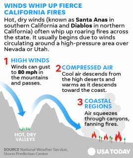
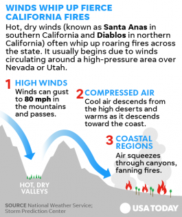
First of all, fires move rapidly. You can be in no danger whatsoever and just see a fire on the distant horizon, and then minutes later, it’s at your back door. Secondly, they change courses. Many times, the fire gets ahold of some new fuel – like a home, tall grass, or trees, and the course veers in that direction. Finally, high winds have propelled these fires rapidly and fanned them to new heights. Every fall, California has something called the “Diablo Winds.” These are seasonal gusts that can reach as high as 80 mph and cause extremely high fire danger. When coupled with existing fires, it’s nothing less than the perfect storm.


http://www.theorganicprepper.ca/wp-content/uploads/2017/10/6364332809325... 126w, http://www.theorganicprepper.ca/wp-content/uploads/2017/10/6364332809325... 252w, http://www.theorganicprepper.ca/wp-content/uploads/2017/10/6364332809325... 55w, http://www.theorganicprepper.ca/wp-content/uploads/2017/10/6364332809325... 269w, http://www.theorganicprepper.ca/wp-content/uploads/2017/10/6364332809325... 84w, http://www.theorganicprepper.ca/wp-content/uploads/2017/10/6364332809325... 101w, http://www.theorganicprepper.ca/wp-content/uploads/2017/10/6364332809325... 265w, http://www.theorganicprepper.ca/wp-content/uploads/2017/10/6364332809325... 143w, http://www.theorganicprepper.ca/wp-content/uploads/2017/10/6364332809325... 336w" style="width: 560px; height: 667px;" />
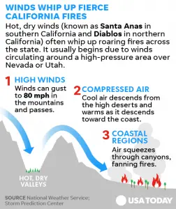

October is often the worst month of the year for wildfires in California. Not only is it the time when the Diablo winds (or Santa Ana winds in Southern California) kick up, but it’s also the driest month. California has a long dry season. It isn’t unusual to go without a single drop of rain from May through the end of October. Because of this, all the lush grass that grows during the spring rainy season is dried, crisp, and tragically perfect fuel.


In situations like this, there is often little to no warning before the fire is roaring through your property. The fire may be miles away and heading in the opposite direction one minute, then turn on a dime. Then suddenly, you find yourself directly in the path of an inferno. If you’re lucky, you escape unscathed with your life but lose all your worldly possessions. Many people have not been lucky.


15 large wildfires are blazing through Northern California’s wine country. 40 people are confirmed dead, hundreds are missing, more than a 100,000 have evacuated, and nearly 6000 homes and businesses have been completely burned to the ground. Thus far, the damage estimate is more than 3 billion dollars.


The following videos and stories show you what the Northern California wildfires are really like.


This video is shot from a fire engine from Berkeley, California on the day Santa Rosa burned. It gives you the firefighters’ firsthand view of the destruction and the speed with which it was wrought.


This video shows the utter devastation from the wildfires and includes clips of people escaping with only their lives.


These two roommates left with their dogs as the fire jumped the hill behind their home, narrowly escaping death. (Strong language)


This police officer’s body camera shows the terrifying scene when he was helping people evacuate.


This couple described their escape as being like “driving through hell.”


This video shows multiple clips of people fleeing the blaze as embers rain down and the billowing smoke gets closer. They are trappd on the freeway in slow-moving traffic.


In one tragic story, a family tried to evacuate by car. Their car caught on fire and they had to take off on foot to try and outrun the blaze. They got separated in the smoke. A 14-year-old boy burned to death and the other members of the family are burned over more than half their bodies. The mother and daughter were found by a neighbor and the father was found by paramedics. (source)


In a story with a happier ending, a farmer tried to evacuate his dogs but one refused to go. Odin, a Great Pyrenees, stayed with his herd of goats. The owners were positive they’d never see their beloved dog again, but when they returned to the farm, they discovered a slightly singed Odin with every member of his herd unharmed. This very good boy had even picked up a few baby deer. (source)


Haunting drone footage shows what Santa Rosa looks like after the fire.


While I strongly recommend evacuating in a situation like this, one man stayed behind and managed to save his home and his neighbor’s home from the wildfire.


Along the Napa/Sonoma border, these residents scrambled for safety and barely escaped with their lives. There were fires in all directions, blocking escape routes. People had to choose whether to drive through blinding smoke or flames.


This couple survived a wildfire they couldn’t escape by taking refuge in a neighbor’s swimming pool for SIX hours as the fire blazed all around them.


Another couple who tried to take refuge in a pool was not so fortunate. The woman died in her husband’s arms after 60 years of marriage.


This family’s dog ran away in a panic and they had no option but to leave. They returned home, certain their beloved pup had perished, but then they found this:


These interviews tell the stories of more narrow escapes.


This aerial footage gives you a better idea of what firefighters are dealing with during these widespread blazes.


More than eleven thousand firefighters are pushing themselves to the limits of their endurance to contain these fires, but they aren’t able to directly respond and save people. As the mayor of Calistoga said in a press conference to the few who opted to ignore evacuation orders, “You will NOT be given life safety support at this point. You are on your own.” Exhausted firefighters are grabbing moments of rest when they can.


In some areas, civilians, farmers, and construction crews have taken a stand to protect their homes from the infernos.


The story of the Capell Valley community is one that was repeated in neighborhoods and valleys across Northern California’s wine country this week, as dry conditions and high winds fueled multiple fires in Sonoma, Napa, Yuba and Mendocino counties.


It was not only firefighters who stood in the path of the blazes, but civilians too. Contractors, skilled construction workers and even former wildland firefighters came out of the woodwork to run bulldozers and drive multi-thousand gallon water tenders on twisty and damaged back roads.


They picked up what tools and equipment they could and tried to save their neighborhoods….


This wasn’t the first time Gil Pridmore had fought a fire in those hills. He spent years as the boss of a California Department of Forestry and Fire Protection bulldozer crew and fought the 1981 Atlas Peak Fire.


He used this experience to help lead a team of 30 people to cut multiple layers of firelines on the rim of the valley.


When flames would breach their lines and encroach on houses, the goal was to get the house “in the black,” or completely surrounded by burned areas so there was no fuel left to catch fire. (source)


They managed to save all but one home in the valley.


A few things to learn from the California wildfires


There are lessons to be learned from these videos (and 5 years of living in fire-prone California.) Wildfires happen in other parts of the United States as well, and it’s important to be prepared before the first spark.


You need a fire kit in your vehicle at all times. Things to include:


  • Swimming goggles: This will protect your eyes and help keep you from being blinded by smoke

  • Respirator masks: This doesn’t mean you will be able to breathe if the fire sucks all the oxygen from your environment, but it will help to filter out some of the smoke so you aren’t disabled by a coughing fit.

  • Fire extinguisher: In a worst case scenario if your vehicle catches on fire, you may be able to put it out if you attack while the blaze is small.

  • Welding gloves: Remember the guy who burned his hands opening a gate? Welding gloves will offer some protection from hot surfaces.

And here are some tips.


  • Do not wait for the official order: In some parts of Sonoma County, people are questioning why an evacuation alert never came. While officials do their best, YOU are the person who is responsible for your family’s safety. (source)

  • Have more than one escape route: In situations like this, you will often find your escape route blocked. Have more than one way out. Figure these out ahead of time and now when you are fleeing for your life and blinded by smoke.

  • Evacuate large animals ahead of time. If possible, evacuate your livestock before the emergency becomes a crisis. In a situation like this, animals can be fearful and uncooperative. Get your livestock to safety first, because if you have to rush out like many of these families did, you’ll have to leave them behind, helpless. I shared good news stories above, but a friend of mine in California went to help out with veterinary rescue. There are far more bad news stories.

  • Leash or crate pets early on: They will be affected by the same kind of panic. A normally well-behaved pet could rush off into danger, leaving you to make the choice to leave them behind or risk your family’s lives trying to save them.

  • Grab your dirty clothes hampers: If you have time to grab a few things unless you have just done laundry, grab dirty clothes hampers. They’re likely to have several days of clothing from the skin out, PJs, and socks, saving you time from searching for all those things individually.

  • Keep precious items and documents in one area: Make sure irreplaceable things are kept together. We have a decorative trunk near the door into which we can sweep precious mementos. Important documents are backed up in the Cloud, which means we don’t have to spend time packing those.

The fires are beginning to be contained, and firefighters say they are gaining an edge. Two out of three of the most destructive fires are more than 50% contained. Some people in Sonoma will be allowed to return to their homes today – or what’s left of them. Winds have lightened, but the weather will still be hot and dry until Thursday when there is a small chance of blessed rain. (source)


I wish those in the affected areas the very best.

Sunday, October 15, 2017

Watch: Berkeley firefighters arrive in Santa Rosa, encounter devastation


Watch: Berkeley firefighters arrive in Santa Rosa, encounter devastation


On Monday at 5 a.m., Berkeley Fire Engine 6 was dispatched to help a neighboring department in Sonoma. It had little idea of what was to come.


The three firefighters who shot and edited the film published here — acting captain Kyl Fleming, apparatus operator Clifford Broome and firefighter Mike Shuken — happened to be working together at Station 6 that morning, although they usually work at different stations, Shuken told Berkeleyside.


The engine joined another four from San Francisco and a leader, creating a strike team that headed north.


The crews knew barely anything about their assignment, simply that they would be assisting with an incident called the Tubbs Fire.


When they arrived in Santa Rosa the firefighters discovered a horrifying scene, including hundreds of destroyed homes on block after block of still-burning lots, one of which — they later learned — belonged to one of their Berkeley Fire colleagues.


The video tells a powerful story.


Read more at Berkeleyside


Please donate to help us continue our mission: 
 https://www.oathkeepers.org/product/donate/


If you would prefer to write a check: Oath Keepers, 5130 S. Fort Apache Rd. Ste. 215, Las Vegas, NV 89148


Tuesday, October 10, 2017

Santa Rosa California Wildfires Force Evacuations, Kill 10 People, Destroy Homes


Photo Credit: Karl Mondon/Bay Area News Group

Photo Credit: Karl Mondon/Bay Area News Group


Fast-moving wildfires have already killed ten people in California, destroyed numerous homes, and spurred the evacuation of about 20,000 people. Santa Rosa is burning, and the death toll is expected to rise.


The Sonoma County Sheriff’s Office said seven people had died in Santa Rosa. “That number’s going to change,” Sonoma County Sheriff Robert Giordano said of the death toll in his jurisdiction. Officers are still searching for people to evacuate and rescue, he said, and “it’s just logical” more bodies will be found.


The fires ignited Sunday night and Monday and spread with alarming speed because of dry conditions, Cal Fire Director Ken Pimlott said at a news conference. According to CNN, more than 20,000 people evacuated, some with little notice. The fires have already destroyed an estimated 1,500 structures and have burned through 57,000 acres in eight counties.


Jesus Torres of Napa said a neighbor called to tell him the fire was bearing down on his house, CNN affiliate KPIX reported. “We gathered up a few of our things and our pets and headed out to our car,” Torres said. “We could see the sky was turning red. … We didn’t know (about the fire) until the last second. There was smoke all over the area.”


The first known fatality occurred as a result of the Redwood Complex fire in Mendocino County, Mendocino County Sheriff spokesperson Captain Greg Van Patten said. Cal Fire tweeted that two people died in the Atlas Fire in Napa County. The fire left whole blocks of residences in smoking ruins and destroyed landmark buildings like the Fountaingrove Inn, a 124-room hotel; a nearby event center, the Fountaingrove Round Barn; and classrooms at the Luther Burbank Center for the Arts, the Santa Rosa Press Democrat reported.


A large part of the town was evacuated, including Kaiser Permanente Hospital and Sutter Hospital. More than 100 patients were treated at Napa and Sonoma area hospitals because of fire-related injuries and issues, said Vanessa DeGier, spokeswoman for St. Joseph Health. Santa Rosa Memorial also accepted 12 patients from the two nearby hospitals that evacuated, including expectant mothers, she said. “Our hospitals are beginning to see patients with injuries incurred as a result of evacuation. This includes victims of car crashes and injuries from falling,” a statement from St. Joseph Health said.


Authorities imposed a sundown-to-sunrise curfew for parts of the city under evacuation orders. “I’m lucky,” Santa Rosa Mayor Chris Coursey said at a news conference. “My house is fine. My family is fine. My city is not.”


A separate wildfire in Anaheim, in Southern California, has spread to 4,000-5,000 acres and burned at least six buildings.  This fire is being dubbed the “Canyon Fire.”


Click here to subscribe: Join over one million monthly readers and receive breaking news, strategies, ideas and commentary.

Gas Masks, Filters, Body Suits, Anti Radiation Pills

Please Spread The Word And Share This Post


Author: Mac Slavo
Views: Read by 139 people
Date: October 10th, 2017
Website: www.SHTFplan.com


Copyright Information: Copyright SHTFplan and Mac Slavo. This content may be freely reproduced in full or in part in digital form with full attribution to the author and a link to www.shtfplan.com. Please contact us for permission to reproduce this content in other media formats.


Tuesday, September 26, 2017

Evacuations Underway In California As Fire Rages Along The Highway


canyonfire


Corona, California is experiencing burning hillsides near a freeway as the Canyon fire rages on.  So far, the fire has forced people to quickly evacuate their homes.


The fire has destroyed more than 1,700 acres of land near Chino Hills State Park, California, with emergency crews urging people to evacuate all homes and schools in the area. The canyon fire began close to Freeway 91 just after 1 pm on Monday and has now spread to over 2,000 acres, according to the Orange County Fire Authority.


The blaze, which is only 5 percent contained, according to the fire service’s latest updates, has necessitated the use of aircraft and more than 300 firefighters.  Four schools have been closed due to the threat from the flames, with Corona City authorities urging people to leave their homes south of Green River Road to the Trudy Way area.


An evacuation shelter has been opened at the Corona High School gymnasium.


Safety precautions need to be at the forefront as the fire is now burning dangerously close to the 91E Freeway.


Click here to subscribe: Join over one million monthly readers and receive breaking news, strategies, ideas and commentary.

Gas Masks, Filters, Body Suits, Anti Radiation Pills

Please Spread The Word And Share This Post


Author: Mac Slavo
Views: Read by 1 people
Date: September 26th, 2017
Website: www.SHTFplan.com


Copyright Information: Copyright SHTFplan and Mac Slavo. This content may be freely reproduced in full or in part in digital form with full attribution to the author and a link to www.shtfplan.com. Please contact us for permission to reproduce this content in other media formats.


Friday, July 7, 2017

G20 HELL: HAMBURG EXPLODES IN FIRE, CHAOS


G20 HELL: HAMBURG EXPLODES IN FIRE, CHAOS


Leaders and wives trapped, city on fire at G20